One of Pieter Bruegel the Elder’s greatest patrons was Niclaes Jongelinck, who owned 16 of his paintings. The paintings were hung at Niclaes Jongelinck’s villa, called ‘Hof Ter Beke’, which was then located outside of the city walls of Antwerp.
Sadly, Niclaes Jongelinck’s house is no longer standing. As I was preparing for a trip to Antwerp, I thought it would be interesting to attempt to locate where his house would have stood in present-day Antwerp. I set about trying to locate his house in the hustle and bustle of modern-day Antwerp.
I enlisted the staff at Antwerp’s Urban Planning, Archaeology and Monuments Department in helping me pinpoint the exact location where his house would have stood. The Antwerp team indicated that it was very difficult to locate the exact position of the original building on a present day map as displayed on 17th century maps. The old maps do not have the necessary precision to use them in a computer geographical information system (GIS). However, as you will read, they did provide remarkable insight into the likely location of the house.
The Antwerp team reported that one author, Rutger Tijs, indicated that the house of Jongelinck is located between the Hof Ter Bekestraat, Sint-Laureisstraat, Haantjeslei and Pyckestraat. According to Van Weghe, in 1885 the then-opened Moonstraat ran across the estate, which the Antwerp team thinks is the last ‘Hof Ter Beke’. (The current site is industrial buildings.) The Antwerp team investigated the site in 2005, but did not find the remains of structures older than the early 20th century.
Others also investigated the likely location of Niclaes Jongelinck’s house. The Antwerp team reported that Plomteux, Prims and Vande Weghe stated that the site where the villa owned by Niclaes Jongelinck once stood can be located between the current streets Hof Ter Bekestraat, Broederminstraat, Lange Elzenstraat and Oudekerkstraat. The Antwerp team agrees with this conclusion and indicate that on the maps of 1617 and 1624 the Jonckelinck villa is clearly shown on the south side of the present day Markgravelei while the other possible location (cf. Rutger Tijs) is clearly indicated on the north side.
According to Vande Weghe, in 1872 a new street called the Jongelincxstraat was opened on the estate witch was then owned by the Van den Broeck family. Prior to their ownership, Madam Schul was the owner. Further, in 1873 a new street, the Coebergerstraat, was opened on the estate. According to the Antwerp team this portion was owned by Van Put and Wilmotte.
The Antwerp team says that it does not seem likely that any of the original buildings survived. According to the list with building permits held at the City Archives, the area was built up in a short period of time from 1872 onward. The largest part of these houses are one family residential buildings dating from 1872 forward.
Niclaes Jongelinck’s villa (indicated on maps in 1617 and 1624 but not on the map from 1698) or at least a building which it replaced is drawn on the 1802 and 1814 cadastral drawings. On the 1836 drawing it is not present. The Antwerp team assumes that it was demolished somewhere between 1814 and 1836. When the Antwerp team tried to project the 1814 drawing on a geographical information system present day map, it seems that the buildings location is under or in the neighborhood of the present day building Coebergerstraat 35-37. The team indicates that the precision of this location is as good as the precision of the 1814 map and the number of comparison points they found. Thus, they conclude that an error of a few meters, but not more, is possible.
The map that you can see below shows a portion of the 1814 map with the current map imprinted on it in red. The two above mentioned places are marked with a purple circle. (You can download the PDF by clicking on the “Villa with current map” link below.)
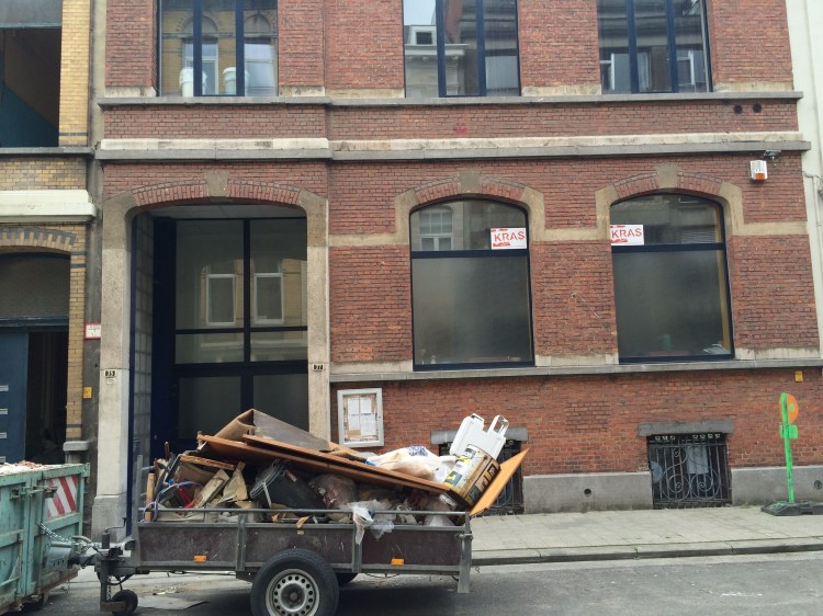
So, for those going to Antwerp, we at Bruegelnow.com recommend a visit to Coebergerstraat 35-37!

Here is a current view of Coebergerstraat 35-37
————————————————————————–
Many thanks to Georges Troupin, technisch bestuursassistent, Stad Antwerpen, Stadsontwikkeling, archeologie, monumenten- en welstandszorg, for his substantial assistance solving this puzzle!
The following literature was quoted:
Greet Bedeer en Luc Janssens, Steden in beeld, Antwerpen, 1200-1800, Brussel 1993
Guido De Brabander, Na-kaarten over Antwerpen, Brugge 1988
G. Plomteux G. & R. Steyaert met medewerking van L. Wylleman, Inventaris van het cultuurbezit in België, Architectuur, Stad Antwerpen, Bouwen door de eeuwen heen in Vlaanderen 3NC, 1989 Brussel – Turnhout.
Floris Prims, De littekens van Antwerpen, Antwerpen 1930
Floris Prims en H. Fierckx, Atlas der Antwerpsche Stadsbuitenijen van 1698, Anterpen 1933
Rutger Tijs, de twaalfmaandencyclus over het leven van Pieter Bruegel als interieurdecoratie voor het huis van plaisantie ‘ter Beken’ te Antwerpen. in J. Veeckman (red.) Berichten en Rapporten over het Antwerps Bodemonderzoek en Monumentenzorg 3, Antwerpen 1999, p. 117-133.
Roberd Vande Weghe, Geschiedenis van de Antwerpse straatnamen. Antwerpen 1977.
Cartographic sources are below:
Marchionatus Sacri Romani Imperii, in P.Keerius, La Germanie Inférieure.1617 Library UFSIA
Marchionatus Sacri Romani Imperii, Claes Janszoon Visscher 1624 City Archive
Dubray, Plan du territoire de la ville d’Anvers divisé en 5 sections, levé géométriquement par Dubray arpenteur géographe du Depart[ement] des 2 Nethes en l’an X 1802, City Archive 12#3944
Dubray en J. Witdoeck, Plan de la cinquième section IIIeme partie lévé géométriquement par Dubray arpenteur géographe du Departement des Deux Nethes en l’an X”; “Renvoi indicatif du supplement des parties qui ont été fait au plan d’après l’Atlas [met legende] fait par moi géomètre soussigné, le supplement à ce plan […] et conformement à l’Atlas du 15 Mars 1812. Anvers, le 21 Decembre 1814, F.D. Witdoeck. 1814 City Archive 12#4270
C.J. Van Lyre, Atlas der Antwerpsche Stadsbuitenijen. 1698. Cf. literature Prims
J. Witdoeck, 5e wijk genaamd extra muros der stad Antwerpen. 1836, City Archive 12#3077
Alouïs Scheepers, Plan géométrique parcellaire et de nivellement de la ville d’Anvers et des communes limitrophes dressé et gravé à l’échelle de 1 à 5000 par Alouis Scheepers conducteur des travaux communaux au service de Monsieur Th. Van Bever, ingénieur de la ville, publié sous les auspices de l’administration communale. 1868. 1868, City Archive 12#8824
Alouïs Scheepers, Plan geometrique parcellaire et de nivellement de la ville d’Anvers et des communes limitrophes dressé et gravé par Aloïs Scheepers, conducteur de travaux communaux au service de monsieur G. Royers, ingénieur de la ville publié sous les auspices de l’administration communale. Edition de 1886. 1886, City Archive 12#12541

I have been studying the painting, The Cripples, by Bruegel. In so doing I learned that Jongelinck had two houses in Antwerp. One, De Sphera Mundi, is on the north side of the Kipdorf just outside the old city walls, number 19. It still stands and you can see it in Googlearth and Googlemaps.
I have a new spin on the above referenced painting, should you be interested:
https://kellapitter.wordpress.com/2017/02/02/a-new-look-at-an-old-painting/
Thanks for your site,
Kathleen Kelly
Posted by kellapitter | February 16, 2017, 3:02 pm